Position
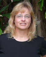
Associate Professor, Department of Geosciences
Education
PhD. - University of Calgary, Canada
MSc. - University of Calgary, Canada
BSc. - University of Regina, Canada
Research
Dr. Delparte has an extensive background in the applications of GIS and remote sensing to the fields of geosciences, resource management and conservation/environmental planning. Dr. Delparte's current research focus relates to Unmanned Aircraft Systems (UAS), visualization, modeling and analysis. She is using 3D platforms (Vive, VR headsets) to visualize her research work with photogrammetry, Structure from Motion (SfM), LiDAR and UAS point-clouds. Recent research relates to precision agriculture, conservation mapping, coral/benthic modeling, avalanche flow modeling and hazard mapping, and land cover change.
Selected Publications
- Burns, J. & Delparte, D. (2017). Comparison of Commercial Structure-From Photogrammety Software Used for Underwater Three-Dimensional Modeling of Coral Reef Environments. ISPRS-International Archives of the Photogrammetry, Remote Sensing and Spatial Information Sciences, XLII-2/W3, 127-131. https://doi.org/10.5194/isprs-archives-XLII-2-W3-127-2017
- Forbey, J. S., Patricelli, G. L., Delparte, D. M., Krakauer, A. H., Olsoy, P. J., Fremgen, M. R., Nobler, J. D., Spaete, L. P., Shipley, L.A., Rachlow, J. L., Dirksen, A. K., Perry, A., Richardson, B. A., Glenn, N. F. (2017). Wildlife Biology. Emerging technology to measure habitat quality and behavior of grouse: examples from studies of Greater Sage-grouse. https://doi.org/10.2981/wlb.00238
- Wu, D., Delparte, D., Sanger, H., Boyack, D., Ogle, J. (Forthcoming). Integrating GIS visualization through a web mapping application to enable public involvement in city planning: A case study of Portneuf River Vision Study. GI_Forum, 4-7 July 2017, Salzburg, Austria. http://epub.oeaw.ac.at/gi_forum
- Burns, J., Delparte, D., Kapono, L., Belt, M., Gates, R., Takabayashi, M. (2016). Assessing the impact of acute disturbances on the structure and composition of a coral community using innovative 3D reconstruction techniques. Methods in Oceanography. 15, pp. 49-59. https://doi.org/10.1016/j.mio.2016.04.001
- Li, Y., Wu, D., Thring, R. W., Delparte, D., & Li, J. (2016). Bathymetric modeling of sediments and organic carbon of polluted rivers in southeastern China. Journal of Soils and Sediments, 16(9), 2296–2305. https://doi.org/10.1007/s11368-016-1451-0
- Forbey, J., Patricelli, G., Delparte, D., Krakauer, A., Olsoy, P., Fremgen, M., Nobler, J., Glenn, N., Spaete, L., Richardson, B., Shipley, Mitchell, J. (2016) Overview of a Workshop to Expand the Use of Emerging Technology to Understand the Ecology of Grouse in a Changing Climate. Grouse News 52: 7-18. https://www.fs.usda.gov/treesearch-beta/pubs/53353
- Burns, J., Delparte, D., Gates, R., & Takabayashi, M. (2015). Integrating structure-from-motion photogrammetry with geospatial software as a novel technique for quantifying 3-dimensional ecological characteristics of coral reefs. PeerJ 3:e1077. https://doi.org/10.7717/peerj.1077
- Carthen, C., Rushton, T., Johnson, C., Hesson, A., Nielson, D., Worrell, B., Delparte, D., Johansen, J., Anderson, J., Lew, R., Wood, N., Zeigler, M., Dascalu, S., Harris, F. (2015). Design of a Virtual Watershed Client for the WC-WAVE Project. Collaboration Technologies and Systems (CTS), 2015 International Conference, IEEE. 90-96. https://doi.org/10.1109/CTS.2015.7210405
- Burns, J. H. R., Delparte, D., Gates, R. D., & Takabayashi, M. (2015). Utilizing underwater three-dimensional modeling to enhance ecological and biological studies of coral reefs. The International Archives of Photogrammetry, Remote Sensing and Spatial Information Sciences, XL-5/W5, 61-66. https://doi.org/10.5194/isprsarchives-XL-5-W5-61-2015
- Delparte, D. M., Belt, M., Nishioka, C., Turner, N., Richardson, R. T., & Ericksen, T. (2014). Monitoring tropical alpine lake levels in a culturally sensitive environment utilizing 3D technological approaches. Arctic, Antarctic, and Alpine Research, 46(4), 709–718. https://doi.org/10.1657/1938-4246-46.4.709
- VanZandt, M., Delparte, D., Hart, P., Duvall, F., & Penniman, J. (2014). Nesting Characteristics and Habitat Use of the Endangered Hawaiian Petrel (Pterodroma sandwichensis) on the Island of Lāna’i. Waterbirds, 37(1), 43–51. https://doi.org/10.1675/063.037.0107
- Wu, J. X., Delparte, D. M., & Hart, P. J. (2014). Movement Patterns of a Native and Non‐native Frugivore in Hawaii and Implications for Seed Dispersal. Biotropica, 46(2), 175–182. http://doi.org/10.1111/btp.12087
- Richardson, R., Kalvaitis, D., & Delparte, D. (2014). Using systematic feedback and reflection to improve adventure education teaching skills. Journal of Experiential Education, 37(2), 187-206. https://doi.org/10.1177/1053825913503116
- Patrick M.R. & Delparte D. (2014). Tracking dramatic changes at Hawaii's only alpine lake. Eos, Transactions American Geophysical Union, 95(14), 117-118. http://onlinelibrary.wiley.com/doi/10.1002/2014EO140001/pdf
- Giambelluca, T.W., Chen, Q., Frazier, A.G., Price, J.P., Chen, Y.L., Chu, P.S., Eischeid, J.K. and Delparte, D.M., (2013). Online rainfall atlas of Hawai ‘i. Bulletin of the American Meteorological Society, 94(3), 313-316. https://doi.org/10.1175/BAMS-D-11-00228.1
- Delparte, D., Peterson, M. R., Perkins, J., & Jackson, J. (2013). Integrating Gaming Technology to Map Avalanche Hazard. Proceedings, 2013 International Snow Science Workshop, Grenoble, France 625–631. http://arc.lib.montana.edu/snow-science/objects/ISSW13_paper_O2-22.pdf
- Delparte, D., Peterson, M. R., Perkins, J.*, & Jackson, J*. (2013). Integrating Gaming Technology to Map Avalanche Hazard. Proceedings, 2013 International Snow Science Workshop, Grenoble, France 625–631. http://arc.lib.montana.edu/snow-science/objects/ISSW13_paper_O2-22.pdf
- Melrose, J. and D. Delparte. 2012. Hawaii County Food Self-Sufficiency Baseline. County of Hawaii Research and Development Department. 212pp. http://kohalacenter.org/wp/wp-content/uploads/2014/05/BASELINE_FOOD_SUSTAINABILITY_WEB.pdf
- Delparte, D., Jamieson, B. and Waters, N. (2008). Statistical runout modeling of snow avalanches in Glacier National Park, Canada. Cold Regions Science and Technology. 54(3), 183-192. https://doi.org/10.1016/j.coldregions.2008.07.006
- Delparte, D. (2008). Avalanche Terrain Modeling in Glacier National Park, Canada. PhD Thesis. Department of Geography. University of Calgary, Calgary, AB, Canada, pp 179. http://www.collectionscanada.gc.ca/obj/thesescanada/vol2/002/NR38205.PDF
- Delparte, D. M. (2006). The Use of GIS in Avalanche Modeling. Knowledge Media Technologies, First International Core-to-Core Workshop. No. 21, Dagstuhl, Germany. http://citeseerx.ist.psu.edu/viewdoc/download?doi=10.1.1.465.6979&rep=rep1&type=pdf
- D'Eon, R.G. & Delparte, D. M. (2005). Effects of radiocollar position and orientation on GPS-radiocollar performance, and the implications of PDOP in data screening. Journal of Applied Ecology. 42(2), 383-388. http://dx.doi.org/10.1111/j.1365-2664.2005.01010.x
Donna Delparte, PhD
Associate Professor,
Department of Geosciences
Idaho State University
921 S 8th Ave, STOP 8072
Pocatello, ID 83209-8072
Phone: 208-282-4419
Fax: 208-282-4414
Email
